Why a River Changes Shape When Seen from Above
See why a river changes shape from above, and learn how height, angle, and landscape context reveal bends, tributaries, and the flow between them.
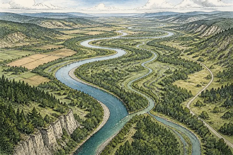
The most common mistake in aerial river photography is to point straight down and treat the water as a ribbon. From that angle, a bend can look like a loop, a tributary can disappear into a dark patch, and the river’s connection to its valley is easy to miss. The view from above changes the apparent shape because it makes relationships visible that the riverbank hides.
To read those relationships in a photograph, work from the broad landscape toward the water’s smaller details. Start with a viewpoint that shows where the river sits, then adjust height and camera angle until bends, tributaries, and the surrounding land make sense together.
What changes when you gain height?
At ground level, a river is usually experienced in fragments: a reach glimpsed between trees, a bend hidden behind a bluff, or a tributary noticed only where it meets the main channel. Elevation brings those fragments into one view. The river’s course becomes a line through a larger setting rather than a strip of water bordered by nearby banks.
That wider context can make a winding river appear smoother or more tightly folded. A low view emphasizes each near curve because close banks occupy a large part of the scene. From higher up, those near-and-far differences shrink, so the sequence of bends reads as a connected pattern.
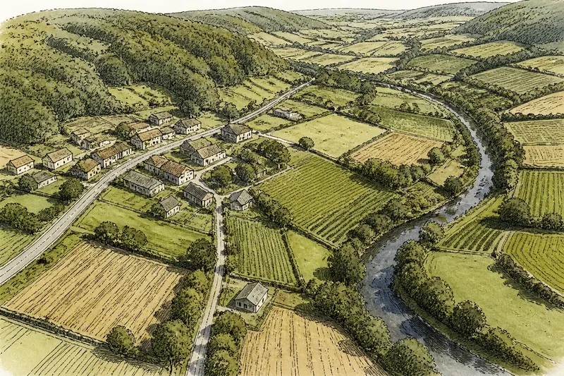
Height also shows what the river is doing in the landscape. A broad valley may contain a narrow active channel; a wooded floodplain may conceal side channels; a tributary may approach through a separate valley before joining the main stream. These are not changes to the river itself. They are changes in what the photograph lets you compare.
Where should you place the viewpoint?
Choose a position that includes a useful stretch of river and enough surrounding land to explain its course. A viewpoint directly over one bend can reveal the curve clearly, but it may crop away the tributary or valley that gives the bend context. A more oblique position may show less of the channel’s exact outline while revealing how the water threads through the terrain.
Before composing, identify the visual question you want the frame to answer. Are you showing the rhythm of several bends, the meeting of two waterways, or the contrast between a river and its floodplain? That decision guides where to stand, hover, or direct the camera, and what to leave around the water.
For aircraft or drones, use lawful flight locations and keep clear of restricted areas, people, and wildlife. The best photographic position is not worth pursuing if reaching it requires unsafe or prohibited flying.
How should you set the camera angle?
A straight-down angle makes the channel’s plan—the path as seen from overhead—easy to follow. It can be effective for a sharply defined meander or a branching network. Yet it suppresses the sense of depth: a steep valley wall, a raised bank, or a tributary entering from a higher slope may look like a flat patch of color.
Tilt the camera toward the horizon when the surrounding relief matters. An oblique angle can reveal valley sides and distinguish foreground from distance. It also changes apparent distances: land near the camera may look larger, and a far bend may seem compressed. Treat that perspective as part of the image, not as a neutral diagram.
Try a modest tilt first, then compare the river’s readability with the landscape’s depth. If the channel becomes hard to trace, move closer to a downward view. If the frame looks like an isolated squiggle, include more of the valley or approach at a shallower angle. The aim is not a perfect geometric outline; it is a view in which the water’s course and setting support each other.
How can you make bends and tributaries legible?
Look for visual cues that distinguish one waterway from another. A tributary may be narrower, may enter at an angle, or may carry a different amount of sediment. A confluence can appear as a junction, but banks, shadows, vegetation, and changing water color can obscure the meeting point. Keep enough space around the junction for the viewer to see both streams approaching it.
Bends become easier to read when the frame includes both sides of the curve and some of the land between neighboring loops. Avoid placing a bend’s apex against a similarly curved road, field edge, or shadow if the lines merge. A slight change in viewpoint may separate them without requiring a tighter crop.
Light matters because it gives texture to water and land. Low, angled light can pick out banks and relief, while overhead light may flatten the terrain. But strong reflections can mask the water’s surface, and deep shadows can make a tributary seem to stop. If the river’s shape is the subject, favor lighting that separates channel, bank, and floodplain rather than dramatizing them at the expense of clarity.
What should you check before making the frame?
- Trace the main channel. Follow it through the whole frame; if it vanishes behind a ridge or tree cover, decide whether that interruption is meaningful or confusing.
- Find every visible tributary. Check whether each one reads as a separate stream and whether its meeting point with the main river is included.
- Inspect the bend sequence. Make sure the curves can be followed without mistaking a road, field boundary, or shadow for water.
- Read the valley around the river. Include enough terrain to show whether the channel lies in a broad plain, a confined valley, or a wooded corridor.
- Watch the frame edges. A tributary or bend cut off at the edge can look accidental; shift the composition or make the crop intentional.
- Check for misleading surface cues. Reflections, sediment, and shadow can alter apparent boundaries, so use surrounding banks and vegetation to clarify the channel.
Not every detail deserves rescue. It is usually not worth trying to show every small side channel, patch of water, and bank in one frame. If the central course reads clearly, secondary details can remain subtle.
What questions help you read a river from above?
Why does a river look straighter from a high viewpoint?
Elevation puts more of the channel into one view and reduces the visual dominance of nearby bends. The river has not straightened; the broad course is simply easier to compare across the frame.
Why can a tributary disappear in an aerial photograph?
Tree cover, shadow, similar water and land tones, or a steep camera angle can hide its channel. Include the surrounding valley and look for the tributary’s approach line, not just a bright or dark strip of water.
Is a straight-down view always best for showing a river’s shape?
No. It clarifies the channel’s outline, but an oblique view can reveal valley relief and the way tributaries enter from the surrounding land. Choose the angle that answers the photograph’s main question.
How can you tell whether two waterways meet?
Look for both channels continuing toward a shared junction, then follow the downstream course beyond it. A change in color or width can help, but the banks and the channels’ alignment provide useful context when surface appearance is ambiguous.
How can one view bring the whole river together?
Say you are photographing a river that bends through a wooded plain, with a smaller stream approaching from a shallow side valley. From directly overhead, the bend is clear but the tributary’s origin blends into the trees. You shift to a slightly oblique angle and include more of the side valley; the expected result is a frame in which the bend remains traceable and the smaller stream’s approach becomes easier to understand.
That choice captures the central value of an aerial viewpoint: it lets viewers connect a river’s local shape to its larger setting. For a photograph about why a river changes shape from above, decide what relationship matters most, choose a height and angle that reveal it, and leave enough surrounding land for the water to make sense. The strongest frame does not merely show a winding line; it shows what the winding line belongs to.