A Slow Look at a Coastline Photograph
A slow look at a coastline photograph reveals how shore, water, buildings, and frame edges work together, without mistaking a striking pattern for the whole story.
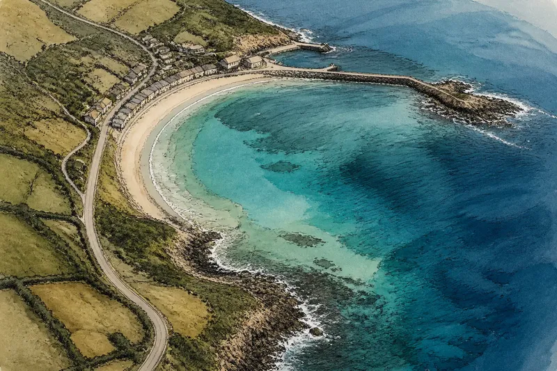
The most common mistake with a coastline photograph is to name the beach and move on. That costs you the image’s quieter structure: a harbor wall bending against the tide, pale water tracing a shallow shelf, or buildings pressed close to a shore that seems empty from above. A slow look at a coastline photograph is a single, continuous viewing exercise; you shift attention through the frame, rather than returning to it at separate times.
Set aside one unhurried stretch of time. You need only the full image, a notebook, and a pencil. Keep the photograph at its original proportions, and begin with the whole frame. Each pass below is a change of focus within the same sitting, not a separate session or a test of what you can identify.
What can you see before naming it?
Look at the whole frame without writing. Notice where your eye lands first, then where it travels. A bright strip of surf, a dark inlet, or a road cutting toward the water may draw attention, but hold back from deciding what it means.
On a notebook page, make two columns: “visible” and “guess.” Put direct observations in the first: a curved pale band, a cluster of small rectangles, a dark line crossing the water. Put interpretations in the second: a beach, houses, a breakwater, perhaps. This distinction keeps description separate from inference.
Trace the strongest visual route with your finger in the air, not on the image. Does your gaze move from land to water, follow the shore, or stop at a prominent structure? Note the route in a few words. The point is to notice how the photograph directs attention, not to find one correct reading.
How does the shoreline change direction?
Shift your attention to the boundary between land and water. Follow it slowly from one side of the frame to the other, or as far as it remains visible. Notice bends, narrow points, coves, straight stretches, and places where the boundary becomes hard to distinguish.
At each change, ask what is physically visible. Is the edge a smooth tonal shift, a ragged line of foam, a seawall, or a band of wet sand? Mark uncertain sections with a question mark rather than filling them in from memory. From above, features can look alike when scale and texture are compressed.
A curve does not explain its own cause, and one image may not show whether a channel is natural or constructed. Record how the edge appears in this frame instead of trying to reconstruct everything that shaped it.
What does the water reveal?
Now look for changes within the water. Compare color, brightness, texture, and visible streaks. A smooth patch beside a textured one may catch your eye; a plume-like band may run parallel to the beach. Describe its location and direction without assigning a cause the image cannot establish.
Check how water meets structures and land. Around a pier, harbor mouth, or offshore rock, do tones and surface patterns shift? Record the visible relationship, such as “lighter patch beside the wall.” Tide, weather, depth, and image processing can all affect appearance, so a single aerial view rarely settles why a pattern looks as it does.
It is not worth the effort to enlarge every speck or identify every vessel. Magnification can turn pixels into confident-looking shapes without adding reliable detail. Zoom in only to inspect a feature you already noticed in the full frame, then return to the whole image.
Where do built forms meet the coast?
Look across the land for buildings, roads, seawalls, piers, docks, and other visible human-made forms. Note where they cluster, then compare their placement with the shoreline. Do structures sit back from it, follow its curve, cross it, or gather around an inlet?
Keep the description specific but modest. “A row of pale roofs beside a straight road” is more defensible than naming a neighborhood or guessing what the buildings are used for. If a form disappears under shadow or merges with a road, leave the uncertainty visible in your notes.
Say you are looking at an invented coastal aerial photograph with a crescent-shaped bay and a short row of roofs near its inner edge. First, note the visible shapes and their location: pale rectangles cluster beside the bay. Next, trace a narrow line that appears to connect them to the frame’s lower corner, marking it as uncertain if it fades into shadow. Finally, compare the cluster with the shore and write that the roofs sit near the bay’s inner edge. The resulting description records placement and a possible connection; it does not claim who lives there or why the road was built.
What changes when you inspect the frame edges?
Move your attention around the perimeter. Start at each corner, then follow each border inward. Look for a road cut off by the frame, a shoreline that continues beyond it, a partly visible structure, or a strong dark shape that pulls the eye outward.
Ask what the edges leave unresolved. A coast that exits the frame may continue in a direction the photograph does not show. A harbor cropped at one side may appear isolated even if connected to a larger settlement beyond the view. Treat what is absent as a limit of the photograph, not evidence that a feature has no continuation.
Compare the edges with the center. Does the image place its clearest detail near the middle, or does a cropped feature carry equal weight? Write one sentence about how the boundaries shape your reading. This is a look at composition, not a reason to infer the photographer’s intention.
Which questions help you slow down?
How can I tell where the shoreline ends?
Follow the visible transition between land and water, and note where foam, shadow, wet sand, or a built edge makes it ambiguous. Describe the uncertain stretch instead of forcing a precise boundary.
Can water color identify depth?
Color alone cannot settle depth from one photograph; light, bottom material, haze, and image processing can change its appearance. Record the color pattern and its position without treating it as a depth reading.
Should I identify every building?
No. Group visible structures by location, shape, or relationship to roads and shore. Naming a specific use or place is unnecessary unless the image itself makes that identification clear.
What if I do not know the coast?
You can still describe its forms, textures, and connections without knowing its name. If location later matters, use a reliable caption or source as separate context rather than folding a guess into what you see.
How can you finish the same sitting?
Return your gaze to the full image and read your notes once. Circle one observation from each pass: an initial visual route, a shoreline change, a water pattern, a built form, and an edge detail. Then write a short description using only what the frame supports, followed by one question it leaves open.
For a slow look at a coastline photograph, that distinction is the useful finish: careful seeing can make a landscape richer without pretending a single view explains it all. Keep the open question beside your description. It gives the next viewer a place to begin, while leaving the coast itself larger than the frame.